Hurricane bearing down on Florida’s Gulf Coast, north of Tampa
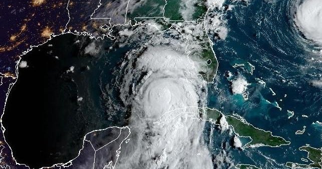
With the 5 p.m. advisory, Hurricane Idalia became a powerful Category 2 storm.
The storm was about 195 miles SW of Tampa Bay with maximum sustained winds of 100 mph. It was moving north at 16 mph.
WATCHES AND WARNINGS
CHANGES WITH THIS ADVISORY:
A Hurricane Watch has been issued from the mouth of the St. Mary’s River northward to Edisto Beach.
A Storm Surge Watch has been issued from Beaufort Inlet to Drum Inlet, North Carolina, as well as the Neuse and Pamlico Rivers.
A Tropical Storm Warning has been issued from South Santee River northward to Surf City, North Carolina. A Tropical Storm Watch has been issued north of Surf City to the North Carolina/Virginia border, including Pamlico and Albemarle Sounds.
The Hurricane Watch from Englewood to the Middle of Longboat Key has been discontinued.
The Storm Surge Watch has been discontinued south of Bonita Beach, Florida.
SUMMARY OF WATCHES AND WARNINGS IN EFFECT:
A Storm Surge Warning is in effect for…
* Englewood northward to Indian Pass, including Tampa Bay
A Hurricane Warning is in effect for…
* Middle of Longboat Key northward to Indian Pass, including Tampa Bay
A Tropical Storm Warning is in effect for…
* Dry Tortugas Florida
* Chokoloskee northward to the Middle of Longboat Key
* West of Indian Pass to Mexico Beach
* Sebastian Inlet Florida to South Santee River South Carolina
A Storm Surge Watch is in effect for…
* Bonita Beach northward to Englewood, including Charlotte Harbour
* Mouth of the St. Mary’s River to South Santee River South Carolina
* Beaufort Inlet to Drum Inlet North Carolina
* Neuse and Pamlico Rivers North Carolina
A Hurricane Watch is in effect for…
* Mouth of the St. Mary’s River to Edisto Beach South Carolina
A Tropical Storm Watch is in effect for…
* Lower Florida Keys west of the west end of the Seven Mile Bridge
* North of Surf City North Carolina to the North Carolina/Virginia border
* Pamlico and Albemarle Sounds
A Hurricane Warning means that hurricane conditions are expected somewhere within the warning area. Preparations to protect life and property should be rushed to completion.
A Storm Surge Warning means there is a danger of life-threatening inundation, from rising water moving inland from the coastline, during the next 36 hours in the indicated locations. For a depiction of areas at risk, please see the National Weather Service Storm Surge Watch/Warning Graphic, available at hurricanes.gov. This is a life-threatening situation. Persons located within these areas should take all necessary actions to protect life and property from rising water and the potential for other dangerous conditions. Promptly follow evacuation and other instructions from local officials.
A Tropical Storm Warning means that tropical storm conditions are expected somewhere within the warning area.
A Storm Surge Watch means there is a possibility of life- threatening inundation, from rising water moving inland from the coastline, in the indicated locations during the next 48 hours.
For a depiction of areas at risk, please see the National Weather Service Storm Surge Watch/Warning Graphic, available at hurricanes.gov.
A Hurricane Watch means that hurricane conditions are possible within the watch area.
A Tropical Storm Watch means that tropical storm conditions are possible within the watch area, generally within 48 hours.
Additional warnings will likely be required tonight or on Wednesday.